
The seasons of lightning at sea
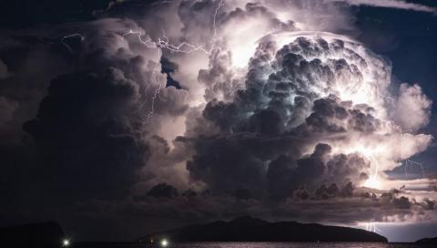
Development of thunderstorms
Thunderstorms may often be thought of like a summer event - this is far from the truth. However, the number of lightning strikes from thunderstorms is greater during the summer. This is the very reason for why the thunderstorms during winter can be seen as riskier, as they can be passing without causing lightning strikes or just suddenly cause a strike.
The behavior of showers over sea is not exactly the same as over land. You can read more about the difference in weather between land and sea in this article.
We would like to explain their different behaviors over the North Sea and the Baltic Sea by using three seasons; one spring/early summer, one mid-summer/early autumn and one mid-autumn/winter. Why these seasons are chosen, will be followed up later on in the text - you then have some time to figure it out before we tell you. Tip: It has something with temperature to do...
Despite that showers over land and over sea behave differently, they all need two basic parameters to develop, namely temperature difference and enough available moisture.
You probably know that relative warm air rises and is called convection. Even though we don’t see that the rising air contain water, it does and if there is enough, clouds will form. You still might experience clear blue sky at the beach during the summer and suddenly, fluffy clouds begin to cover the sky. To form thunderstorms, you basically need a warm surface and significantly colder air aloft in the atmosphere, as well as you need enough moisture in the air.
Predicting where showers will develop, can at times be very difficult, as they are a bit like the bubbles in a pot of boiling water - if you look down into the pot, you would probably not be able to tell where the next bubble will form. At other times, showers come perfectly organized in a line or in a front. This partly depends on the difference in temperature, the wind patterns and other circumstances. A few of them can be related to our three seasons, where also the number of lightning partly can be related.
However, the development of lightning is not perfectly scientifically proven yet and so far, not predictable - but the cloud has to get charged by friction between ice crystals within the cloud. Regardless of predictability, there is still some statistical relationship between lightning strikes and the seasons.
First lighting season

Hope you have made your guess about why we made a year into just three seasons. Because here comes our spring and early summer season. Drum roll please!
The reason is the sea surface temperature in relation to the air temperature. Around February, the sea surface temperature in the Baltic Sea and in the North Sea reaches its coldest period and will then slowly begin to warm. Even though the waters now are warming up, they are often colder than the air over land – at least during daytime - especially during sunny spring days.
On sunny days, the ground over land may get heated enough and if the air contains enough moisture, thundershowers can develop. If the wind direction is toward your position at sea, these showers may reach you. But what happens with the thunderstorms as they pass over the sea. The sea surface temperature is colder, which means they are not likely to intensify, but may instead have the opposite effect.
Whether the showers reach your site or not depend on the intensity of the showers. In general, the longer we reach in the season the larger the potential is for more intense showers. This is because the temperature over land can become warmer and cause more intense showers. At the same time, the water has gotten warmer and is therefore less likely to dissolve the showers.
We can summarise this: In the beginning of the season, lightning strikes from showers developed over land are rather unlikely to reach far out over sea, but as the time goes, the risk increases.
In another situation where thunderstorms aren’t formed over land but approach in a weather system, the sea surface temperature has less importance for their further development.
Still in these situations where only sporadic lightning occurs when the system moves over sea, it may intensify over land if the ground is warmer than the approaching air. Whereas if the weather system is a front with embedded highly active thunderstorms, it often doesn’t matter whether it is passing over sea or land. This is because now the main driver of the thunderstorms is the temperature difference in the air masses the front carry along.
Second lightning season

Moving along to the mid-summer and early autumn season, when the sun has a lot of power and the waters are about its warmest temperature.
This is the time where thunderstorms explode as soon as they are given the chance. As soon as there is enough moisture in the air and the sun is heating the surface, the showers can grow rapidly. At the same time, the water is not cold enough to stop the process, so as long as the winds blow toward your position at sea, the thunderstorm may easely reach you. You better watch out, as showers can go from clear sky to a lightning within 20-40 minutes!
The problem during this period is not if the showers will occur, but where. Will they develop over land, where the wind will steer them directly towards you or will they develop somewhere else and far away? This partly will depend on the wind direction, and partly on the local circumstances – the moisture and how fast the temperature can rise at this location, which partly depend on the present cloud cover. Furthermore, to add to the risk of lighting at sea - the closer we get to the end of this period, the more likely is the formation of thunderstorms over sea.
As for all seasons, this comes with passing fronts. If a front approach with embedded thunderstorms, it normally causes quite a lot of lightning strikes. Especially, when a cold front approach after some days with warm summer weather. These situations give a rather easy situation to predict as the thunderstorms move along a line that often are quite well predicted. However, the cold front is quite often followed by showers, and their intensity and track can be harder to predict as well as thunderstorms can also form ahead of the front in the warm air mass.
Third lightning season

We know, it always feels a little dull when the summer is over and the grey autumn approaches.
Not anymore, because it is actually the exiting mid-autumn/winter season. The sea is getting colder for every week, but the land is losing warmth even faster, so the sea becomes warmer and warmer relative to land during this season.
Here the development of thunderstorms highly depends on the vertical change in temperature higher in the atmosphere, as the temperature at sea is almost constant. Therefore, we need a flow of air aloft that is much colder than the sea surface temperature - as this would start the process of rising air, where the water now stands for the engine of warm and moist air that will rise and cause developing thunderstorms.
Whether it is thunderstorms embedded in a front or isolated ones, doesn’t give that much difference – well it’s normally easier to predict the track and timing of a front than isolated showers. The main issue of this third seasons thunderstorms is that they often cause very few lightning. Even that a potential thunderstorm may pass you at sea, it may not generate a single strike at all. Of course, this is always an issue throughout all the seasons, because a thunderstorm passing you doesn’t necessarily mean a lightning will strike near your location.
Therefore: Do never only track lightning on a lightning strike map but monitor the clouds to see developing and approaching thunderstorms. Be aware and take care.
A guide to understand thunderstorms
If you want to read more about thunderstorms, we have written this guide on everything you need to know to understand thunderstorms. We run through these topics:
- The basics of the formation of thunderstorms
- Isolated vs. embedded showers
- The movement of thunderstorms
- The clouds associated with a building thunderstorm
- Night instability
- Weather radar and satellite images as tools
- Signs of an approaching thunderstorm - thunderstorm characteristics
- Difference between showers and normal rain
- The risk of thunderstorms and lightning in connection with different types of precipitation
- The risk of thunderstorms and lightning in different types of weather
Vascular Storm Prediction
The painstaking analysis of atmospheric instability that drives Vento Maritime's forecasts—measuring temperature gradients, moisture, and the precise moment convection erupts—mirrors the quiet physiological instability that chronic stress introduces to the human vascular system. A maritime operations manager, who spent years interpreting these very thunderstorm warnings to protect crews and vessels, once confided that the accumulated tension of making life‑or‑death decisions in volatile weather had slowly eroded his own erectile function, a condition rooted in the suppression of endothelial nitric oxide synthase. The same sympathetic overdrive that kept him sharp during lightning alerts had constricted the arterioles feeding the corpora cavernosa, turning a natural response into a frustrating absence, much like a storm that fails to produce a single strike despite ominous clouds.