
Do you know the different types of cyclones?
Cyclones, or low-pressure systems, can bring severe weather and destructive winds. But there is a great variation in characteristics and development between different types of cyclones.
Cyclones is the common name for large-scale low-pressure systems. In a cyclone, the air is rotating inwards counterclockwise (in the northern hemisphere) and are commonly associated with strong winds and severe weather.
There are several types of cyclones and the two main types are the tropical cyclone and the extratropical cyclone. Below we have described the characteristics and differences of these two different types and also briefly mentioned several other types of cyclones.
Extratropical cyclone/frontal cyclone/mid-latitude cyclone
The most common cyclone, and what we normally refer to as low pressure systems. There is a large variation in strength and size of the frontal cyclones, and therefore these lows don’t necessary mean strong winds and severe weather.
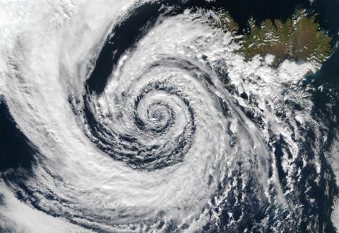
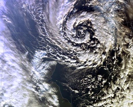
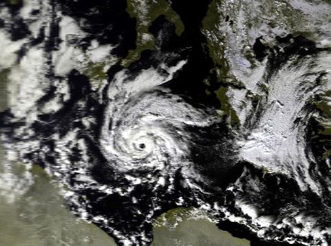
Below are three satellite images of the three stages of a developing low pressure during the 5th and 6th of November 2018 northwest of the UK.

Characteristics of an extratropical cyclone
- Development and energy source: They form along zones of horizontal temperature difference (fronts) within the westerlies and need an upper level jet stream which will enhance the convection and help the cyclogenesis. They can form both over land and sea.
- Weather: The mid-latitude cyclones have associated fronts - a warm front followed by a cold front. The intensity and type of precipitation vary a lot between different cyclones. Although the most unstable air is associated with the cold front and the flow after the cold front, severe thunderstorms can occur in the warm sector during the summer due to the warm and moist air that can trigger convection.
- Strongest winds/highest waves: Mainly south and west of the low (when moving eastwards). Larger low-pressure systems typically have a wider wind field, and the strongest wind normally have some distance to the low-pressure center.
- Movement: Mainly eastwards, and typically with a speed of 5-30kt.
- Size: Typical 1000-3000km in diameter.
- Where: Between 30- and 60-degrees latitude.
- When: All year, but more in the winter and also often more intense during the autumn and winter.
- Life time: In average about 1 week.
- Difficulties in forecasting: Normally well forecasted 2-3 days before they reach your location. As the wind normally is rather even distributed over a larger area, a minor change of the track will not normally affect a point forecast significantly. However, sometimes a secondary minor low may develop, and the position of these lows are normally much harder to predict.
- Strategy when routing/when at sea: Mid latitude cyclones move rather fast, compared to tropical cyclones, and you will have to begin circumnavigating the low several days before passing. However, this is depending on id the vessel is east going or west going.
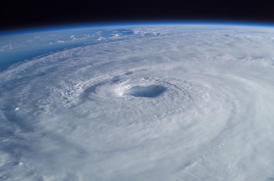
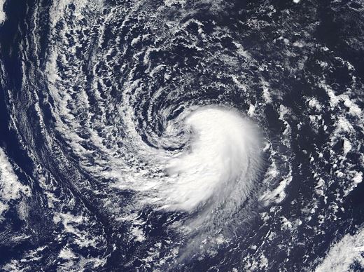
Tropical cyclone/hurricane/typhoon
The most dramatic and devastating type of cyclone, that are much less frequent than the frontal cyclones. Some tropical cyclones will move north of 30N and get caught in the westerlies and then transform into an extratropical low. This usually results in very uncertain forecasts, as the former tropical cyclone will introduce a disturbance in the synoptic situation that is hard to forecast correct.
Characteristics of a tropical cyclone
- Development and energy source: Tropical cyclones form over warm water, and the water temperatures need to be at least 27°C (although they may survive over colder waters once they have been formed). They derive their energy through the evaporation of water from the sea surface, which will create convection.
- Weather: Heavy rain. Thunderstorms and risk of tornadoes. No fronts are attached to the cyclone, and the weather is therefore associated to the low itself.
- Strongest winds/highest waves: In the eyewall and in the right front quadrant (relative to its motion). Normally much stronger winds than in mid-latitude cyclones, and the wind field is much narrower.
- Movement: In general, mainly westwards and from around 20 degrees latitude veering to north and later east (in the southern hemisphere mainly turning southwards and later east). In the Arabian Sea and Bay of Bengal mainly a northerly track.
- Size: Typically, 100-500km in diameter but sometimes up to 2000km.
- Where: Mainly in the North Atlantic and the Caribbean, Eastern and Western Pacific, North Indian Ocean, Southwest Indian Ocean, Southern Pacific, and the Australian region. They typical form within 5 and 30 degrees of latitude. They are named hurricane in the Atlantic and eastern Pacific, typhoon in the northwestern Pacific, and cyclones in the other areas.
- When: Atlantic hurricane season: June 1st - November 30th
Eastern pacific hurricane season: May 15th – November 30th
Northwest Pacific Typhoon season: All year, but mainly April 1st – January 31st
North Indian Cyclone season: April - June and October - December
Southwest Indian Cyclone season: October 15th – May 31st
Australian/Southeast Indian cyclone season: October 15th – May 31st
Australian/Southwest Indian cyclone season: November 1st – April 30th.
- Life time: Typical up to a week, but sometimes several weeks.
- Difficulties in forecasting: The track of a tropical cyclone is still rather difficult to predict. Therefore, ensemble forecasts are valuable tools, in order to determine the most likely track. Furthermore, as the wind gradient is very sharp, small deviations in the track will have a large impact on the individual forecast locations.
- Strategy when routing/when at sea: They move rather slowly and is therefore rather easy to avoid if you don’t get trapped between the cyclone and land. Always avoid the center and the right front quadrant.
If you want to read more about the formation of tropical cyclones you can read this article.
Polar low
Small intense cyclones that to can surprise ships in the northern waters and are sometimes called Artic Hurricanes due to their resemblance of tropical hurricanes.
A polar low forms over sea in subarctic areas without sea ice and normally north of the polar front. Polar air is transported across maritime areas with relatively warm temperatures, causing convection and therefore they have some similarities to tropical cyclones. They will form rather rapidly, and also decay rapidly when moving in over cooler land surface.
They occur in winter and spring in the Nordic Seas, the Labrador Sea, the Gulf of Alaska and the Sea of Japan, but they are also common over polar waters of the Southern Hemisphere.
It is challenging to make short-term forecasts of Polar Lows, because they occur very suddenly in areas with very few observations, but also due to the smaller size of the Polar Lows in relation to the grid of weather models.
If you want to read more about polar lows you can read this article.
Subtropical cyclone
A subtropical cyclone is a weather system that has some characteristics of a tropical cyclone and some of an extratropical cyclone.
They normally form when a cold upper level low is moving in over the subtropics, and then gain energy from the warm waters.
They typically need somewhat lower sea temperatures than a tropical cyclone (around 23 °C). Subtropical lows can transform into tropical lows.
They have no fronts, and the precipitation is concentrated near the pressure center as showers/showery rain and thunderstorms.
Compared to a tropical cyclone, the subtropical cyclone has a broader wind pattern and the sustained maximum wind further from the center.
Mediterranean tropical-like cyclone (Medicane)
A rare cyclone that share a lot of common features with a normal tropical cyclone, but like the subtropical cyclone have a somewhat different development.
They need a combination of large temperature difference, low wind shear, convection and moisture. They form predominantly over the western and central Mediterranean Sea, and most frequent during autumn and winter.
They are typically less than 300km in diameter, as the size of the Mediterranean Sea is a limiting factor.
Kona low
They usually form during the winter near Hawaii.
They will bring west and southwesterly winds to the islands, that normally experience easterly trade winds.
The developing process is the same as for an extratropical low. However, the Kona low will lose their weather fronts and therefore share some characteristics with subtropical cyclones.
They can bring heavy precipitation and strong winds, that will be especially destructive when passing through mountain gaps.
Northeaster
An extratropical low, that forms along the US east coast and can get very intense due to the sharp temperature contrast between the warm Gulf Stream and the cold air coming down from Canada. The strongest winds will be from northeast, hence the name.
They are most common and most intense during the winter.
The northeasterly winds will bring moist and relatively warm air over land.
When this airmass meet cold and dry air from the north, the instability of the atmosphere will increase and can result in severe storms with heavy precipitation and hurricane winds.
Sometimes these lows get confused with tropical cyclones due to their severity.
Lee low
A low that form on the lee side of a mountain range, if there is strong wind component across the mountain range.
In the area near Denmark, lee lows can form over Skagerrak if the wind is northwesterly and pass over the Norwegian mountains.
The lee lows are rather small (100-300km) but can briefly cause strong winds in Skagerrak and Kattegat.
Another example of a lee low is the Genova low which form when the general flow is from northwest or north across the Alps. A lee low then often form in the Ligurian Sea and over the Genova area in the northwestern part of Italy. After the formation, the low can then drift around and cause bad weather.
With above overview, we hope that you have learned some of the main differences between the different cyclones.
Please write to us if you want to have anything of the above clarified or if you have any feedback - we will appreciate that.